US Military: Finding Surface-to-Air Missile Sites with AI Algorithm
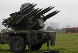
National intelligence agencies typically employ teams of highly trained analysts who use advanced data interpretation techniques to detect nuclear facilities in foreign countries or locate hidden military installations within massive satellite image datasets. Recently, deep learning algorithms developed by American researchers have shown remarkable efficiency, outperforming human analysts by hundreds of times when identifying the locations of surface-to-air missile systems on the mainland.
According to a report from Wired, researchers at the University of Missouri demonstrated that deep learning algorithms can assist even those without prior experience in image analysis to locate surface-to-air missile sites covering nearly 90,000 square kilometers in the southeastern part of a continent. The AI system achieved an overall accuracy of 90% in locating these sites, while human analysts would take around 60 hours to complete the same task—compared to just 42 minutes for the AI model.
The significance of this research lies in the fact that artificial intelligence has proven capable of significantly reducing the workload on human analysts. Companies like DigitalGlobe generate approximately 70TB of raw satellite imagery every day, and this is only from one commercial provider. When considering the vast amounts of data collected by other commercial satellites and government surveillance systems, the scale of the challenge becomes clear.
Researchers have used pre-trained deep learning models to identify objects of interest to intelligence agencies and national security experts. Models such as GoogleNet and Microsoft's ResNet were originally designed for object detection and classification in standard photographs and video content. These models were adapted to analyze satellite images, including both color and black-and-white data.
While analysts have already mapped most known surface-to-air missile sites, AI tools can automatically detect new ones in regions like North Korea or other areas of concern. These new sites often contain high-value assets, making them a key focus for intelligence professionals.
One major challenge in applying AI to satellite image analysis is the lack of a comprehensive training dataset. Deep learning algorithms require large amounts of manually labeled examples to accurately recognize features in satellite imagery.
To address this, the University of Missouri team combined DigitalGlobe satellite imagery with publicly available data from around 2,200 surface-to-air missile sites worldwide, creating a training dataset. They then tested multiple deep learning models to determine which performed best.
Although current AI models face difficulties in analyzing smaller objects like mobile missile launchers, radar antennas, or military vehicles due to low-resolution satellite images, they remain extremely valuable in intelligence operations.
For example, the International Atomic Energy Agency (IAEA) not only monitors declared nuclear facilities but also needs to identify undeclared ones across nearly 200 countries. AI tools can assist the IAEA and other independent organizations in tracking nuclear development and potential weapons of mass destruction, enhancing global monitoring capabilities.
Earth anchors are used in a variety of applications including:
- Retaining wall reinforcement
- Temporary structural support for buildings and tents
- Secured tie down anchorage for floating docks and pipelines
- Utility pole and tower anchors
- Erosion control anchoring
Earth Anchors,M22 M16 Stay Rod Anchor,Galvanized Steel Rod,Hdg Adjustable Anchor Rod
Shahe Yipeng Import and Export trading Co., LTD , https://www.yppolelinehardware.com